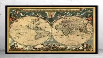
Antique World Maps – A Journey Through Time
Antique world maps are cartographic treasures that offer a glimpse into the historical perception of the world. Crafted between the 15th and 19th centuries, these maps reflect the geographical knowledge and artistic styles of their time. Often adorned with elaborate illustrations, sea monsters, and mythical lands, they were as much works of art as they were functional tools for navigation and exploration. These maps reveal the evolving understanding of continents and oceans, showcasing the adventurous spirit of the Age of Discovery. Today, antique world maps are highly sought after by collectors and historians for their aesthetic appeal and historical significance, serving as enduring symbols of human curiosity and the quest to chart the unknown.

Antique World Maps have long fascinated historians, cartographers, and casual enthusiasts alike. These maps, often beautifully crafted and intricately detailed, serve not only as navigational tools from bygone eras but also as windows into the geographical understanding and artistic sensibilities of past civilizations. My exploration of Antique World Maps has been nothing short of a mesmerizing journey through time, revealing the evolution of human knowledge, culture, and artistry.
Historical Significance and Evolution
One of the most striking aspects of Antique World Maps is their historical significance. These maps offer a glimpse into how ancient civilizations perceived the world and their place within it. Early maps, such as the Babylonian World Map, often depicted a flat earth with a central hub surrounded by unknown territories, reflecting the limited geographical knowledge of their times. As exploration expanded, so did the accuracy and detail of these maps. The Ptolemaic maps, for example, introduced the concept of a spherical earth and utilized a grid system to improve precision.
The Age of Exploration marked a significant turning point in the history of cartography. Maps from this period, such as those by Gerardus Mercator and Abraham Ortelius, began to reflect the discoveries made by explorers like Columbus, Magellan, and Cook. These maps not only provided more accurate depictions of coastlines and continents but also included detailed illustrations of newly encountered flora, fauna, and indigenous peoples. The evolution from mythical and speculative representations to more scientific and empirical depictions is a testament to the advancements in navigation, astronomy, and geography.
Artistry and Craftsmanship
Beyond their historical and geographical value, Antique World Maps are also celebrated for their artistry and craftsmanship. The meticulous hand-drawn illustrations, often embellished with ornate borders, mythical creatures, and allegorical figures, elevate these maps to works of art. The use of color, shading, and calligraphy demonstrates the skill and dedication of the cartographers and artists of the time.
One cannot overlook the beauty of maps like the 1602 Kunyu Wanguo Quantu by Matteo Ricci, which blends Western cartographic techniques with Chinese artistic traditions. Similarly, the maps of the Dutch Golden Age, produced by the likes of Willem Blaeu and Johannes Janssonius, are renowned for their exquisite detail and aesthetic appeal. These maps were not merely utilitarian objects but also symbols of prestige and intellectual achievement, often displayed in the homes of the elite.
Cultural and Political Insights
Antique World Maps also provide valuable cultural and political insights. The way in which different regions and peoples are depicted can reveal contemporary attitudes, biases, and power dynamics. For instance, European maps from the colonial period often portrayed Europe at the center of the world, reflecting Eurocentric worldviews and imperial aspirations. The inclusion of exotic animals and “savage” caricatures of indigenous peoples further underscores the ethnocentric and often patronizing perspectives of the mapmakers.
Conversely, maps from non-European cultures, such as the Islamic and Chinese cartographic traditions, offer alternative viewpoints. The 1154 Tabula Rogeriana by Muhammad al-Idrisi, a map created for the Norman king of Sicily, provides a south-oriented depiction of the world that contrasts sharply with the north-oriented European maps. These cultural differences in mapmaking highlight the diverse ways in which humanity has sought to understand and represent its world.
Educational and Collectible Value
For educators and collectors, Antique World Maps hold immense value. In educational settings, these maps serve as powerful tools to engage students with history, geography, and art. They can spark discussions about exploration, scientific progress, and cultural exchange. The tactile experience of examining an old map, with its aged paper and faded ink, can also foster a deeper connection to the past.
For collectors, Antique World Maps are prized possessions that offer both aesthetic pleasure and historical intrigue. The rarity and condition of the maps, along with their provenance, can significantly influence their value. Serious collectors often seek out maps with unique features or those that mark significant historical events, such as the first map to depict the Americas or the first to show the route of a famous explorer.
Conclusion
In conclusion, Antique World Maps are much more than mere representations of geographical knowledge; they are intricate tapestries woven with history, art, culture, and science. They tell stories of human curiosity, ambition, and creativity, offering us a unique lens through which to view our past. Whether you are a historian, an artist, an educator, or simply a lover of beautiful objects, Antique World Maps have the power to captivate and inspire. As we continue to explore and understand these remarkable artifacts, we gain not only a greater appreciation for the skill and knowledge of our ancestors but also a deeper connection to the ever-evolving story of humanity.


